The Vast Scope of Islamic Geography
Muslim geographers dealt with a vast variety of subjects, and
covered nearly all of the known world of their time. It is
impossible to give justice to all works and authors, and all
that can be attempted here is the sort of outline that shows as
much as possible, whilst trying to cover the vast scope of
subjects covered by Muslim geographers. Focus, first is on the
geographers of eastern Islam.
Amongst the earliest works from the East is Kitab al-Sifat
By Nadjar B. Sumaiyil (b. 740), some chapters of which are
devoted to the sun and the moon, wells and the seas, winds,
snow, and rain.[1]
Al-Jahiz (ca. 776-868) wrote Ajaib al-Buldan (the Wonders
of the World), which discusses amongst other things the
important cities of the Islamic world; his other work, Kitab
al-Hayawan (The Book of Animals) deals amongst other things
with adaptation to environment.[2]
Al-Kindi (813-870) wrote on tides, as well as on the shape and
size of earth, whilst his works on meteorology and geology deal
with physical geography, and his works on medicine supply
information on the distribution of plants and animals.[3]
Ibn Khurdadhbih’s al-Masalik
includes much information on
‘
Al-Biruni
’s
Chronology (al-Athar
. . .)[10]
combines the purely literary and historical sources of medieval
sects and nations with the astronomical lore about their
calendars, feasts, and astronomical parameters used in their
rituals.[11]
Al-Biruni’s discussion of the Jewish calendar, for example, is
the most extensive medieval technical and dogmatic exposition on
the subject; and was never matched, even by the Hebrew sources,
according to Saliba.[12]
Al-Biruni’s
Yaqut al-Hamawi’s (d. 1229) Mu'jam al-Buldan (Dictionary
of Countries),[16]
is an immense compilation of geographical facts 1isted in
alphabetical order, dealing with geography in the broadest
manner-astronomical, physical, historical, and archaeological.[17]
It attempts at fixing the spellings of place names and gives
their geographical positions, boundaries and coordinates.[18]
He covers cities, rivers, mountains and deserts as well as seas
and islands, and he also provides information on eminent
residents of places, adding anecdotes and other interesting
facts.[19]
His work includes accounts from earlier sources and also his own
observations, resulting from his travels to
Ibn
Said al-Maghribi (1214-1274) wrote Kitab al-Djughrafiya
(The Geography Book) where he gives the latitudes and longitudes
of all the places he cites, and where he adds information
provided by contemporaries, which cannot be found in Al-Idrisi,
for instance.[23]
He dwells on the
Al-Dimashqi (d.1326-7), a Syrian descendant of the Ansars (the
early helpers of the Prophet),
[26] wrote Kitab
nukhbat al-dahr fi ajaib al-barr wal bahr (Selection of the
Age on the Wonders of the Land and the Sea).[27]
The book includes such diverse topics as the configuration of
the earth, eleven chapters on the formation of mountains, the
sea and its motions, tides, etc.[28]
The work also gives detailed accounts on the Indian Ocean
,
the Western Pacific, the
Abu’l Fida (b. Damascus
1273-d.
Hama
1331) stands out as one of those singular characters of Muslim
civilisation who fought wars and wrote at the same time (just
like the historian Usama Ibn Munqidh, and the cartographer Piri
Reis). From the age of twelve he fought both crusaders and
Mongols.[31]
His family lost its estates during his youth, which he recovered
in 1312 through his fidelity to the Mamluks
whom he served as vassal
prince until his death.[32]
His treatise Taqwim al-Buldan (A Sketch of the Countries)
was known quite early in the Latin
West, with many
translations of it, either partial or complete.[33]
It includes twenty eight chapters, with a prologue that contains
interesting observations such as the gain or loss of day
according to the direction in which one goes around the earth,
and the assertion that three quarters of the earth’s surface is
covered with water.[34]
Abu’l Fida includes in the introduction al-Biruni’s view on the
terra incognita, quoting al-Biruni’s theory that between
the African continent south of the sources of the Nile and the
terra incognita there were channels of water connecting
the Indian Ocean
with the Atlantic.[35]
It is not unlikely that his work might have reached Tangiers and
might have influenced the Portuguese sailors who searched for an
entry into the Indian Ocean from South Africa.[36]
In the mid 17th century, Abu’l Fida’s work had
an unedited translation by Schickard, and Gravious published in
London extracts relating to Khwarizm and Transoxonia.[37]
A Latin translation was made in Leiden in 1746 by Reiske,[38]
whilst Reinaud and de Slane edited the complete text.[39]
The French translation was by Reinaud and Guyard, completed in
1883.[40]
Possibly one of the most important aspects of Abu al-Fida’s work
was his observations of the spherical shape of the earth;[41]
a crucial matter for the progress of geography, and to receive
more attention further on.
In
Western Islam, the first geographer to mention is Al-Bakri (b.ca
1010; d. 1094) whose Kitab al-massalik wal mamlaik (Book
of the Roads and Kingdoms), completed in 1068, has been
partly preserved.[42]
This work is a description of land and sea routes written in
order to facilitate travel, and which also includes historical
and social data.[43]
It includes a description of Slavic and Nordic peoples, and most
importantly a description of North Africa
and Spain, including
data about the Sahara routes.[44]
Al-Bakri also wrote lexicographical work on place names in
poetry and on the traditions of the Prophet.[45]
Remarkably, for a man who never left the Iberian Peninsula, he
was noted for his methodical approach, his ever alert curiosity,
his attention to detail, and the serious approach to information
of a wary investigator.[46]
Abu
Hamid al-Gharnati (1080-1160), from Grenada
,
made many travels, leaving his home in 1114 for Egypt
,
then returned to his native town, before leaving again in 1117
for Sardinia, Sicily
,
Alexandria, and Cairo
,
then Baghdad
,
Iran
,
crossing the Caspian Sea, reaching the mouth of the Volga. He
then made three journeys to Khwarizm, and visited Hungary,
before passing the last years of his life in Baghdad, Mosul, and
then Damascus
,
where he died in 1160.[47]
It was in Mosul, where he completed his work Tuhfat al-Albab
wa Nukhbat al-Ajaib (A Book of Wonders), which is divided
into four chapters, the first dealing with the world’s
inhabitants; the second making a description of wonders of
countries and unique buildings; the third describing the sea and
its wonderful animals, volcanoes on their islands, etc; the
fourth dealing with tombs and pits containing bones.[48]
The author collected information from witnesses but also from
his own observation. He saw, for instance, the Pillars of
Hercules near Gibraltar a short while before their destruction
in 1145, and he was one of the last persons to see the tower of
Alexandria in its complete form, as well as the obelisk at Ain
Shams, near Cairo, before it crumbled in 1160, and he also
provides valuable information on Europe.[49]
Much of Al-Gharnati’s work can be found in Al-Qazwini’s
and other subsequent Muslim geographers’ works.[50]
The
travels of the Valencia
born, Ibn Jubair (Ibn
Jubayr
)
(d. ca. 1217), offer remarkable accounts, amongst the rarest, of
Muslims living under Christian rule in both Sicily
,
during the reign of William II (the Good) (r. 1166-1189), and in
the East, under crusader hegemony, in the time of Salah Eddin
(Saladin) (d. 1193).[51]
His accounts of Muslims under Christian rule are to this day
used to form a precise picture of Muslim status under Christian
rule in the medieval period as will be seen in Part Three of
this work. The English version tells the reason for his travels,
that as a secretary for the ruler of Granada in 1182, he was
forced by that said ruler to drink seven cups of wine.[52]
To expiate his godless act, Ibn Jubayr decided to perform the
duty of Hajj. He left Granada on 1183 on an itinerary, with all
the stops well marked by two maps, one for the East, and the
other for the West. One of the first places he reached,
Alexandria in Egypt
,
impressed him greatly, especially its famed giant lighthouse.[53]
He says that it was visible from a distance of some seventy
miles, its height 150 times the size of a man, its number of
stairways, entrances and rooms quite amazing, and also including
a mosque built in its summit, thus consecrating a monument from
pagan antiquity to Islam and one Thursday, he himself prayed in
it.[54]
During his stay at Makkah
,
which lasted over nine months, he makes good descriptions of the
sites there, including a visit to Madinah
where lay the tombs of
the Prophet and early caliphs. He then returned home via Kufa,
Baghdad
,
Mosul, Aleppo
and Damascus
,
and on a Genoese ship caught in Acre, he returned west, via
Sicily. Off the coast of Messina, the ship was caught in such a
violent storm, the Christian passengers on board gave in to
despair, while ‘the Muslims submitted themselves to the decree
of the Lord.’[55]
Eventually the passengers survived, and Ibn Jubayr ends his
travel narrations in Sicily, recounting the activity of the
volcanoes, and the life of Muslims under Norman rule. He was
obviously impressed by Palermo
,
which he describes as: ‘the metropolis of the islands, combining
the benefits of wealth and splendour, and having all that you
could wish of beauty, real or apparent, and all the needs of
subsistence, mature and fresh.’[56]
Ibn
Battuta
's
(d 1377) Rihla is an account of travels that took him
from Tangiers through North Africa
,
Syria
,
Iraq
,
Iran
,
reaching India
in 1325.[57]
In 1332, he went overland through Egypt
and Syria; then
Istambul, crisscrossed Asia Minor, crossed the Black Sea to the
Crimea, and made his way overland via the Islamised Mongol
Golden Horde’s territory, through Samarqand, Bukhara
and Afghanistan. He
reached the Indus River frontier of India in late 1333. He
became chief judge of Delhi and in 1342 became the Sultan’s
envoy to the Mongols in China
.
The trip also took him to the Maldives, Bengal, Assam, Sumatra,
and finally to the Chinese city of Zaytun, and possibly Peking.
He returned to Morocco
in 1349, and completed
dictation of his travels to Ibn Jazayy in 1357.[58]
His work was translated into French, and also partially into
English by Gibb.[59]
The merit of Gibb’s version is that it gives a very useful and
lengthy introduction on Ibn Battuta’s life. We learn, for
instance, that during his journey from Alexandria to the
Maghreb, on two occasions, he narrowly escaped capture by
Christian pirates, but still his love for travel was never
exhausted. From
each part visited, Ibn Battuta relates his experiences and
observations. He was particularly interested in political
conditions and the glories of foreign rulers; in economic
factors; in all forms of strange customs, such as those of
marriage and burial, in the construction of Indian beds, and the
kind of fuel used in China.[60]
Ibn Battuta’s accounts of some parts of the world, such as 14th
century India, the Maldives, southern Russia, and Black Africa
remain unique, he being the only medieval author to give some
specific accounts of such places.[61]
On India, for instance, he describes in detail the reign of
Muhammad B Tughluq, and contemporary Delhi, its population, its
size, its diverse parts, its attractive sites, etc.[62]
Ibn Battuta also caught the Muslim world straight in the
aftermath of the Mongol devastation (1253-1320), and thus offers
first accounts of the effects of such onslaught. He also
describes buildings and architectural accomplishments, which are
no more. He speaks, for instance, of madrasas, and also of
hospitals, some of the earliest institutions of Islam, and their
structures,[63]
which have since gone. Also interesting is that he expresses
early Islamic awareness of certain natural manifestations, such
as relating to the River Nile, as he says:
‘The
Egyptian Nile surpasses all rivers of the earth in sweetness of
taste, length, of course, and utility. No other river in the
world can show such a continuous series of towns and villages
along its banks, or a basin so intensely cultivated. Its course
is from south to north, contrary to all other [great] rivers.
One extraordinary thing about it is that it begins to rise in
the extreme hot weather, at the time when rivers generally
diminish and dry up, and begins to subside just when rivers
begin to increase and overflow.’[64]
His
interest in the customs of people is well defined, whether with
regard to the idolatry of the inhabitants of Ceylon, or the
harshness of the Turks
towards thieves, whilst
China
, he
informs us:
‘Is
of vast extent, and abounding in produce, fruits, grain, gold
and silver. It is traversed by the river called the ‘Water
of Life,’ which rises in
some mountains, called the Mountains of the Apes, near the city
of Khan Baliq (Peking) and flows through the centre of China
for the space of six
months’ journey, until it reaches Sin as Sin (Canton). It is
bordered by villages, fields and gardens, and bazaars, just like
the Egyptian Nile, only that this riverside is even more richly
cultivated and populous, and there are many waterwheels on it.
In the land of China there is abundant sugar cane, equal, nay
superior, in quality to that of Egypt
.’
[65]
About the manufacture of Chinese porcelain, he says:
‘The
Chinese pottery [porcelain] is manufactured only in the towns of
Zaytun and Sin
Kalan. It is made of the soil of some mountains in that
district, which takes fire like charcoal, as we shall relate
subsequently. They mix it with some stones which they have, burn
the whole for three days, then pour water over it. This gives a
kind of clay which they cause to ferment. The best quality
porcelain is made from clay that has fermented for a complete
month, but no more, the poorer
quality [from clay] that has fermented ten days… It [porcelain]
is exported to India
and other countries,
even reaching as far as our own lands in the West, and it is the
finest of all makes of pottery.’[66]
Despite all such extensive detailed accounts, just considered,
most such accounts are unique in universal knowledge, whether in
terms of quality, variety, or volume, Ashtor, like most
‘historians’ of geography, derides Muslim geography, putting
focus on what seemingly appear to him are shortcomings of such
geography, for instance, holding that:
‘Muslim writings of the ninth century and early tenth century
reveal an almost complete ignorance of the geography of Europe.
Even the European shores of the Mediterranean
were unknown to the
Arabs. This is a clear proof that there were no trade
relations... All Arab geographers of this period confuse Rome
and Constantinople, and repeat legendary stories.’[67]
This
is baffling when one reads about Islamic geographical
achievements as amply shown already in this chapter, that any
shortcoming, however small, should be amplified so much as to
demean the great accomplishments, a criticism which is also
groundless, and fallacious, for part one of this work has amply
shown that Muslims traded with Europe in the late 7th
and 8th centuries,
and 9th century Western accounts by Church
authorities, themselves, speak of such trade. The biographies of
Pope Gregory IV (Pope 827-844) and of Leo IV (Pope 847-855), for
instance, speak of Spanish textiles along with those of
Byzantium.[68]
As for Muslim geographers’ knowledge of Europe, it was already
well advanced in the 10th century, and had earlier
foundations. Historical evidence proves, as Kramers points out,
that since the 8th century Muslim travellers and
traders are to be found in Italian towns and Constantinople.[69]
Many accounts of other European places were reports of authentic
journeys, such as Ibrahim ibn Ya'qub's journey from Spain to
Germany (ca. 965).[70]
The trips by Al-Ghazal’s diplomatic mission to the Vikings of
Ireland in 845 have been noted.[71]
Dunlop, although himself reserved about whether actually the
Muslims visited such Western shores, except Ireland, still notes
good Islamic knowledge of the Western Christian shores;[72]
and also of the islands lying off the continent of western
Europe and Africa in al-Bahr al-Muhit (the Circumambient
Ocean) otherwise called by such names as Bahr az-Zulmat
(the Sea of Darkness) or al-Bahr al-Akhdar (the Green
Sea).[73]
The British Isles (Jaza'ir Bartaniya or Baruniya-twelve in
number according to al-Battani (850-929), were known, with
Ankartara, Inkiltara, Lanqaltara (l'Angleterre), Squsiya
(Scotia) and Irlanda or Birlanda (Ireland).[74]
Dunlop also tells of the sea adventures of Muslim sailors
departing from Lisbon, and their discovery of unknown lands, an
episode dating from the 9th century.[75]
There is also plenty of evidence to prove the Muslim discovery
of Scandinavia, from as early as the 8th century,
more than fifty Muslim authors writing on the region, the most
comprehensive early accounts of this part of Europe to this day.[76]
Most of these sources have been collected by A. Seippel and
translated into Norwegian by H. Birkeland.[77]
They include historical texts, geography and travellers’
narratives. Ibn Khurdadhbih, for instance, gives information on
trade, rulers, landscape;[78]
Ibn Rusta speaks of trade, urban life, customs, etc;[79]
whilst Ibn Fadlan,[80]
describes the trip,[81]
people and places, and on the manners and customs of the Rus,
their manners of dress, rituals, diets,[82]
the length of day and night, etc.[83]
In
view of all such accounts, which could have been vastly
extended, generalised assertions deriding Islamic geography,
when no other geography can match its richness, especially at
such an early stage, only serve to highlight both poor
scholarship, and narrow hostile writing on the part of
mainstream Western authors.
[1]
In Ibn al-Nadim: Kitab al-Fihrist; ed. Flugel;
[2]
Al-Djahiz: Kitab al-Hayawan;
[3]
J. Jolivet; R. Rashed:
Al-Kindi; Dictionary of Scientific Biography;
Vol 15; Supplement I; pp. 261-6.
Ibn Al-Nadim: The Fihrist of Ibn al-Nadim; edited
and translated by Bayard Dodge (Columbia University
Press; New York; 1970), pp. 615-26.
[4]
S.M.Z. Alavi: Arabic Geography, op cit, p. 27.
[5]
G. Sarton: Introduction: Vol 1; op cit; p. 621.
[6]
Al-Ramhurmuzi: Ajaib al-Hind; Ed Van der Lith (
[7]
Ibid; p. 88.
[8]
S.M.Z. Alavi: Arabic Geography, op cit, p. 76.
[9]
Al-Masu’di: Muruj al-Dahab; ed. De Meynard (
[10]
Al-Biruni
: Chronology of Ancient Nations; Edward C. Sachau
ed. and trans. (1879).
[11]
G. Saliba: Biruni; Dictionary of the Middle Ages,
op cit; Vol 2; pp. 248-51; at op cit; p. 249.
[12]
Ibid.
[13]
Alberuni's
[14]
G. Saliba: Biruni; Dictionary of Middle Ages; op
cit; p. 249.
[15]
Ibid.
[16]
Yaqut, Ibn Abd Allah al-Hamawi: Jacut's
Geographisches Worterbuch, ed. F. Wustenfeld. 6 vols
(Leipzig, 1866-70).
[17]
G. Sarton: Introduction; op cit; vol 2; p. 41.
[18]
S.M. Ahmad: History; op cit; p. 181.
[19]
Ibid.
[20]
C Bouamrane-L Gardet: Panorama de la pensee Islamique
(Sindbad; Paris 1984), at p. 260.
[21]
A. Miquel: Geography, in the Encyclopaedia (Rashed ed),
op cit, pp 796-812 at p 809.
[22]
S.M. Ahmad: History; op cit; p. 181.
[23]
Ibn Said: Kitab al-Jughrafiya; ed. Ismail
Al-Arabi (
[24]
M.A. Tolmacheva: Geography; op cit; 393.
[25]
See L. Bagrow and R.A. Skelton: History of
Cartography (
[26]
G. Sarton: Introduction; op cit; vol 3; p. 800.
[27]
The work was edited by A.F. Mehren; quarto, 375 pp.
(St Petersburg; 1866).
[28]
G. Sarton: Introduction; op cit; vol 3; p. 800.
[29]
Ibid.
[30]
G. Ferrand: Relations de Voyages; pp. 363-93.
[31]
J. Vernet: Abu’l Fida; in Dictionary of Scientific
Biography; op cit; vol 1; pp. 28-9; at p. 28.
[32]
Ibid.
[33]
C. de Vaux: Les Penseurs, op cit, p. 13.
[34]
J. Vernet: Abu’l Fida;
op cit; p.
29.
[35]
I.J. Krckovskij: Izbrannye Socinenja,. op cit;
pp. 394-5.
S.M. Ahmad: History; op cit; p. 197.
[36]
Ibid.
[37]
J. Greaves or Gravius;
(1602-52) (
[38]
J. J. Reiske (Leipzig; 1866; reprinted 1886).
[39]
J.T. Reinaud and Baron de Slane (Paris; 1840).
[40]
J.T. Reinaud and S. Guyard ed: Geographie d'Aboulfeda,
2 vols (Paris, 1848-83).
[41]
Carra de Vaux: Les Penseurs, op cit; pp 21-2.
[42]
J. Vernet: Al-Bakri: Dictionary of Scientific
Biography; op cit; vol 1; p. 413-4. at p. 413.
[43]
Ibid; p. 414.
[44]
Ibid.
[45]
G. Wiet et al: History; op cit; p
.659.
[46]
Ibid.
[47]
S.M. Maqbul Ahmad: History; op cit; p. 167.
[48]
According to S.E. U. Hasham, Dubler published the text
of his work with a Spanish tr.
[49]
S.M. Maqbul Ahmad: History; op cit; p. 168.
[50]
Ibid.
[51]
Ibn Jubayr
: Voyages, trans with notes by M. Gaudefroy
Demombynes (Paris, 1949-65).
[52]
The travels of Ibn Jubayr
; tr from the original Arabic with introduction and
notes, by R.J. C. Broadhurst (J. Cape, London, 1952).
[53]
Ibid; pp. 32-3.
[54]
I.R. Netton: Seek Knowledge; Thought and Travel
in the House of
Islam
(Curzon Press; Richmond; 1996), p. 99.
[55]
Ibn Jubayr
: Travels (Broadhurst) op cit; p. 336 ff.
[56]
Ibid; pp
348 fwd.
[57]
Ibn Battuta
: Voyages d'Ibn Battuta, Arabic text accompanied
by French translation by C. Defremery and B.R.
Sanguinetti, preface and notes by Vincent Monteil, I-IV
(Paris, 1968), reprint of the 1854 ed.
[58]
R.B. Winder: Ibn Battuta
; in The Genius of Arab Civilisation;
J.R. Hayes ed;
op cit; p. 210.
[59]
Ibn Battuta
: Travels in Asia and
[60]
F. Rosenthal: Ibn Battuta
; Dictionary of Scientific Biography; op cit; vol
1; p. 517.
[61]
Ibid.
[62]
Ibn Battuta
: Defremery (ed); vol 2; p. 16; etc.
[63]
F. Farag: Why
[64]
Ibn Battuta
: Travels; (Gibb); op cit; p.52.
[65]
Ibid; p. 282.
[66]
Ibid; pp. 282-3.
[67]
E. Ashtor: A Social; op cit; p. 105.
[68]
G. Migeon: Arts
Plastiques et
industriels; ii; p. 320; in S.M. Imamuddin: Muslim;
op cit; p. 112.
[69]
J. H. Kramers: Islamic Geography and Commerce;
extracted from The Legacy of Islam; edited by T Arnold
and A. Guillaume; pp. 79-106; repr in The Islamic
World and the West; Edited by A.R. Lewis (John Wiley
and Sons, London;
1970), pp.
66-78. p. 76.
[70]
M.A. Tolmacheva: Geography; op cit; 393.
[71]
W.E.D. Allen: The Poet and the Spae-wife; op cit; pp.
1-14.
[72]
D.M. Dunlop: Arab Civilisation; p.160.
[73]
Ibid.
[74]
Qazwini, ed. Wustenfeld, ii, 388;
[75]
See summary of these early voyages of discovery in D.M.
Dunlop: Arab Civilisation; op cit; p.160 ff.
[76]
S.F.D. Hughes:
[77]
Harris Birkeland: Nordens hidstorie I middelalderen
etter arabiskenkilder, Norske Videnskaps-Akademi i
[78]
In S.F. D. Hughes:
[79]
Ibid; pp 706-7.
[80]
M. Canard: Ibn Fadlan, in Encyclopaedia of Islam;
New edition, vol 3 (Brill; Leiden, 1971), p. 759.
[81]
S. Al-Dahhan: Risalat Ibn Fadlan; Dar Sadir (
[82]
For a long account of Ibn Fadlan’s travel to the Volga
Bulgars, see M. Canard: Les Relations de voyage d’Ibn
Fadlan chez les Bulgares de la Volga; In Annales de
l’Institut d’Etudes Orientales; Vol 16; 1958; pp
41-146; for extensive extracts on such travels see S.M.
Ahmad: A History, op cit; and for a summary see
M. Dunlop: Arab Civilisation,
pp 169-70.
[83]
S.M. Ahmad: A History; op cit; p. 328. |
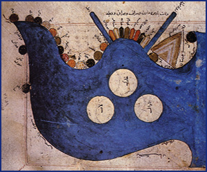
The Persian gulf - Al-Istakhri
- Copyright © 2012 - All Rights Reserved -
- Islamic Civilization