Muslim Geography: Foundations
Exploring Muslim geography, once more, raises the matter of what
factors were behind the sudden drive for geographical knowledge
in early Islam; amongst such factors, the role of the faith
comes to the fore again as the main and crucial factor. Islam
urged people to open their horizons and know about the wonders
of God’s creation, which acted as a fundamental stimulus for
geographical curiosity.
Journeys were also undertaken to build the records of the
Prophet’s sayings (Hadith
) or
for the purposes of administration and trade, or simply to
satisfy curiosity, to say nothing of pilgrimage.[1]
Hence, roughly, the same combinations of observance of the faith
and practical necessities that account for the rise of other
sciences and aspects of Islamic civilisation. These central
elements are considered in succession, beginning with the direct
role of the faith.
The Islamic Faith and the Rise of Islamic Geography
The
rise of Islamic geography does not owe anything to
Islam, first and foremost, regarded a journey to perform the
pilgrimage rites at Makkah
as a duty incumbent upon
every capable Muslim at least once in a lifetime.[2]
And, thus, whilst nearly all early Muslim geographers included
itineraries to Makkah, or placed it at the centre of their maps
(as will be elaborated upon further on), later geographers used
the same pilgrimage, that on particular occasions, lasted over a
decade, and even twenty five years,[3]
to write most elaborate travel and geographical narratives and
treatises. One amongst such pilgrim-scholars was Mohammed
al-Andalusi
(b. in Ceuta in 1259),
who left for pilgrimage, passing through North Africa
, to
Egypt
,
then Syria
,
and who not only wrote on Tradition
,
but also left two travelogues carrying the appropriate title of
rahalat (travels), where he describes his routes, men of
letters, natural history, etc.[4]
More famed, is the traveller Al-Tidjani, who in the year 1309,
left Tunis
to perform his
pilgrimage, and who wrote on his Rihla.[5]
In this travel, he observed everything he could, providing
information not just about the places he visited, but also about
neighbouring territories, providing geographical and historical
information of the first order, which was vastly used by
subsequent writers, whether Ibn Khaldun
, or
Amari, the latter in his history of Muslim Sicily
,
relying heavily on accounts of al-Tidjani about the island.[6]
The great al-Maqrizi (d. 1442), equally, used the occasion of
his pilgrimage to spend four years in the Hijaz, studying the
routes followed by the pilgrims from southern Arabia
and Abyssinia, and
revising the geographical dictionary of al-Himyari, and that was
years before he wrote his famed Khitat (in 1439), which
remains one of the best works on medieval Egypt.[7]
Pilgrimage
could also be combined
with study and trade, two further powerful elements in
geographical knowledge. Bulliet notes how trade and pilgrimage
could be combined without religious objection, and several years
might be spent making the pilgrimage to Makkah from some distant
location.[8]
Another travel objective was the search for religious knowledge,
particularly in the form of traditional lore (Hadith
).
Indeed, some of the sayings of the Prophet explicitly enjoined
such travels in quest of knowledge, but more important as an
inspiration was the educational stricture, which prevailed
through the 11th century, that valid learning was
dependent upon direct oral transmission.[9]
This requirement of an unbroken chain of oral transmission (isnad)
going back to the Prophet, regarded as the best possible
guarantee of authenticity in this vital area of religious
knowledge, made it necessary for the industrious scholar to
spend months or years travelling from city to city to collect
additional lore.[10]
This developed into a tradition whereby virtually every scholar
of significance travelled extensively at some point in his life[11]
and of course wrote on such travels. Remarkably, this tradition
lasted much beyond the early centuries of Islam. Al-Samani
(1113-1167), for instance, was a 12th century
exegesist and a traditionist, who became well known as a
historian, completing the history of
The
compilation of the Prophet’s sayings also influenced Islamic
geography considerably by imposing the strictest compliance with
accuracy and precision. Kimble thus points out, that it is not
surprising to find Muslim scholars, with all their consideration
for the feelings and traditions of the past, submitting their
authorities to severe critical analysis and revising them where
expedient.[16]
Al-Khwarizmi
(d. 835), for instance,
substantially improved Ptolemy’s geography in his Face of the
Earth, as regards both text and maps.[17]
Staying with religious necessity, Sayili notes how mathematical
or astronomical geography was a very important field of
application for astronomy, and religious needs supplied a strong
motivation for work in this field.[18]
Al-Biruni
thus speaks of the need
for the knowledge of geographical locations in determining the
direction of Makkah
which every Muslim has
to face during the prayers, and he also insists on other
benefits. He says:
‘I
believe that this benefit is not limited to this aspect only of
our divine services but that it extends to other things. For
whosoever determines the longitude and latitude of his country
with precision will thereby be enabled to find out the exact
time of noon and afternoon, and of the end of evening twilight
and of dawn, times which are needed not only in connection with
the prayers but also for fasting, and likewise, he will thereby
be in a position to ascertain the times of the new moon,
although the religious law restricts the determination of this
latter to direct observation because of the Tradition
in which the Prophet
(God Blessing be upon him) said: ‘We are people who do not write
and do not calculate; adding: ‘we indicate the month thus and
thus and thus,’ showing the ten fingers three times, ‘then thus
and thus and thus,’ folding the thumb at the third time.[19]
Moreover the usefulness here exceeds religious matters and
extends to worldly affairs, and what has been mentioned is also
beneficial in finding the correct direction towards one’s
destination and is therefore desirable in that it will bring
good and prevent harm.’[20]
Practical Necessities
The
second element in the rise of Islamic geography, like other
sciences, was practical necessity. Ibn Rusta (fl 903) wrote
Kitab al-A’laq al-Nafisa, the introductory pages of which
are devoted to a detailed discussion of the most essential
fundamental astronomical notions for the solution of
geographical problems such as the size and shape of the earth
and the location of places.[21]
This is followed by the study of geography of
One
of the most elaborate of these works
is Al-Muqaddasi’s (d.1000) Ahsan al-Taqasim, the
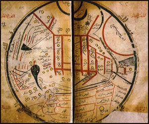
first to produce maps in natural colours.[32]
Ahsan at-Taqasim, completed around 985, after preliminary
chapters on general geographical ideas, gives the geographical
arrangement of its different parts of the Islamic world, and an
approximate estimate of the distance from one frontier to the
other.[33]
The countries that are included are Arabia
,
Iraq
and Mesopotamia, Syria
,
Egypt
,
and the Maghrib
(North Africa
),
Spain, into Transoxiana (W. Turkestan), Khurasan, North-West
Iran
(Azerbaijan, Armenia
Transcaucasia), Jibal, Khuzistan (the South-West, ancient Elam
or Susiana), Fars (Persia
),
Kirman and finally Sind (the valley of the Indus).[34]
Each chapter is generally divided into two parts, the first of
which enumerates the different localities and gives good
topographical descriptions, especially of the principal towns,
whilst the second part lists all sorts of subjects which the
author groups under the label of 'particular characteristics.[35]
It looks at towns, their people, the social and ethnic groups,
commerce, natural resources, archaeological monuments,
currencies, the political situation, a vast array of subjects,
which Al-Muqaddasi himself, defines:
‘I
thought it expedient to single out the chorography of the land
of Islam, comprising a description of deserts and seas, lakes
and rivers, famous cities, resting places and the high ways of
commerce, its exports and the staple commodities; an account of
the inhabitants of different countries; of the diversity of
languages and manners of speech; of their dialects and
complexion, their religious tenets; of their measures and
weight, their coins both large and small; with particulars of
their food and drink, their fruits and waters.. the salt lands,
the rocky wastes and sandy deserts, hills, plains and mountains,
the limestone and sandstone; the fat and lean soil, the lands of
plenty and fertility… the industrial arts and literary
avocations.’[36]
There is, thus, no subject of interest to modern geography,
Kramers says, which is not treated by al-Muqaddasi; Miquel, for
his part, praises him as the creator of ‘total geographical
science.'[37]
Devising maps of regions and countries, as will be amply
explored further on, also arose out of practical necessity.
Bagrow notes how itineraries and route maps had to be compiled
for various purposes such as diplomatic missions into distant
lands, such as to
Also
contributing to geographical knowledge was the vast extent of
the
‘Islam has already penetrated from the eastern countries of the
earth to the Western. It spreads westwards to Spain (Andalus),
eastward to the borderland of China
and to the middle of
India
,
southward to Abyssinia and the countries of Zanj (Africa, the
Malay Archipelago and Java), northward to the countries of the
Turks
and Slavs. Thus the
different people are brought together in mutual understanding,
which only God's own Art can bring to pass..¼’[39]
Bulliet notes how Islamic society was a place where long
distance travel was common, an impression supported by the
rarity of historical evidence of political barriers to travel,
even between hostile states, or by efforts of governments to
control the movements of their subjects.[40]
The measure of a prosperous and strong Islamic state, then, was
that the routes were so secure that travellers could move
wherever they wished without molestation.[41]
Trade
Long-distance trade was well established from the very beginning
of Islam, and was encouraged by religious attitudes developed
within the strongly commercial environment of Makkah.[42]
Trade with, and in direction of,
Trade with
There is a very interesting, little known, work by Jitsizo
Kuwabara, dating from 1935, which deals with the Muslim links
with
These trading contacts had dramatic consequences socially, and
also scientifically. On the first front, the Surname of P’u. P’u
is a transliteration of Abu (Abou), a common Arab name; the Sung
Shih records that in the San fo-ch’I country, a large proportion
of the people are surnamed P’u.[73]
Arab traders brought their wives with them, but a few traders
married Chinese women. A record shows that an Arab marrying a
Chinese lady of the imperial family was promoted to high
official position.[74]
Some of the Arabs also studied Chinese culture and language. The
impact on the sciences and the development of navigation was
equally dramatic. The Chinese knew comparatively early the
polarity of the magnetic needle, but it was the Arabs who
applied it to navigation, and the mariner’s compass was brought
back to
Trade was also a fundamental factor behind Islamic writing on
Korea, and a good number of Muslim geographers wrote on Korea
between the 9th and 15th century, and were
studied by Kei Won Chung and Hourani.[76]
The Muslims used the name al-Shila or al-Sila, after an early
dynasty which ruled there until 935 to refer to
Diplomacy and Politics
Diplomacy and politics, finally, also stimulated geographical
knowledge, a well known instance being that of Ibn Fadlan’s
travels to
In
the year 965, two embassies were sent by Muslim rulers of North
Africa
and Muslim Spain to the
In
the far eastern parts of Islam, Abu Dulaf (born in Yambo, near
Makkah
)
(fl early 10th century) spent his career in
Al-Biruni
,
who spent much of his working life in the court of the Sultan
Mahmud of Ghazna (11th century), accompanied him in
his expedition to
[1]
G.H. T. Kimble: Geography in the Middle Ages
(Methuen &Co Ltd; London; 1938), pp. 48-9.
[2]
R. Bulliet: Travel
and Transport;
Dictionary of the Middle Ages; op cit; vol 12;
pp. 147-8;
p. 147.
[3]
Ibn Jubayr
, for instance, wrote his narratives of travel on the
pilgrimage to Makkah
, which he undertook to expiate a sin (drinking wine).
Ibn Jubayr: Voyages, tr. with notes by M.
Gaudefroy Demombynes (Paris, 1949-65).
Ibn Battuta
also left his
hometown of Tangiers with the intention of pilgrimage to
Makkah
, which he accomplished five times, and all the
adventures in between, he relates in his work. Ibn
Battuta: Travels in Asia and Africa; trans and
selected by H.A.R. Gibb;
Routledge;
[4]
I.J. Krckovskij: Izbrannye Socinenja;. Pp. 382-3.
[5]
H. H. Abd-al-Wahab: Rihlat al-Tijani;
[6]
I.J. Krckovskij: Izbrannye Socinenja;. Pp. 383-4.
[7]
Ibid. pp. 525-6.
[8]
R. Bulliet: Travel
and Transport;
op cit; p. 147.
[9]
Ibid.
[10]
Ibid.
[11]
Ibid.
[12]
I.J. Krckovskij: Izbrannye Socinenja. op cit; pp.
319-20.
[13]
I.J. Krckovskij: Izbrannye Socinenja; 319-20. See
also S.M. Ahmad: History; op cit; p. 179.
[14]
I.J. Krckovskij: Izbrannye Socinenja; 319-20.
[15]
I.J. Krckovskij: Izbrannye Socinenja; 319-20. See
also S.M. Ahmad: History; p. 179.
[16]
G.H. T. Kimble: Geography; op cit; pp. 48-9.
[17]
This work was accompanied by a map of the world executed
by al-Khwarizmi and sixty nine other scholars at the
instigation of Al-Mamun; in G.T. Kimble: Geography;
Note 1; p. 49.
[18]
A. Sayili: The Observatory
; op cit; p. 24.
[19]
See Bukhari: Sahih; Book 30 (on fasting) section 13. and
Muslim: Sahih; Book 13; tradition 15.
[20]
Al-Biruni
: Tahdid al-Amaqin; op cit; pp. 323-4.
[21]
Ibn Rusta: Kitab al-A’laq al-nafisa; ed De Goeje
(Leyden; 1892), vol vii.
[22]
Ibid.
[23]
Texts and translations: First edition with French
translation and notes by C. Barbier de Meynard: le Livre
des routes et des provinces; Journal Asiatique,
vol 5, 1-127, 227-95, 446-532, (1865).
A better text has been published by M.J. de Goeje, with
French translation and notes: Bibliotheca
geographorum arabicorum, 6 (
[24]
G.R. Tibbetts: The Balkhi School of Geographers in
History of Cartography (Harley-Woodward ed); op cit;
pp. 108-29; at pp. 117.
[25]
Al-Ya'qubi: Les pays, tr.
G. Wiet (
[26]
G.R. Tibbetts: The Balkhi School of Geographers; op cit;
p. 117.
[27]
Carra de Vaux: Les Penseurs, op cit, p. 3.
[28]
G.R. Tibbetts: The Balkhi School of Geographers; op cit;
pp. 116-7.
[29]
Ibid; p. 117.
[30]
Al-Muqaddasi:
Ahsan at-taqasim fi Ma'rifat al-Aqalim;
M.J. de Goeje ed., Bibliotheca Geographorum
Arabicum, 2nd edition., III vols (
[31]
C. de Vaux: Les Penseurs; op cit, pp 27-8.
[32]Al-Muqaddasi:
Ahsan at-taqasim;
op cit.
[33]
D.M. Dunlop: Arab Civilisation 800-1500 A.D
(Longman Group Ltd, 1971), p. 166.
[34]
Ibid.
[35]
Ibid.
[36]
Al-Muqaddasi: Ahsan al-Taqasim; op cit; pp. 1-2.
[37]
In D.M. Dunlop: Arab Civilisation; op cit; p.
166.
[38]
L. Bagrow: History of Cartography; Revised and
Enlarged by R.A. Skelton (C. Watts and Co Ltd; London;
1964), p. 54.
[39]
In
The Book of the Demarkation of the Limits of the
Areas
In N. Ahmad, Muslim Contribution to Geography
(Lahore: M. Ashraf, 1947), p 35.
[40]
R. Bulliet: Travel
and Transport,
op cit; pp.
147-8.
[41]
Ibid.
[42]
Ibid; p. 147.
[43]
Relations des Voyages faites par les
Arabes et les Persans dans l'Inde et a la Chine,
ed. et tr.
Langles et Reinaud, 2 vols (Imprimerie Royale; Paris;
1845).
[44]
G. Sarton: Introduction; op cit; vol 1; p.636.
[45]
Edited by Reinaud (
[46]
S.M.Z. Alavi: Arab Geography (The Department of
Geography; Aligarh; 1965), p. 33.
[47]
In Carra de Vaux: Les Penseurs de l’Islam;
op cit; pp. 53-9.
[48]
S.M.Z. Alavi: Arab Geography; op cit; p. 33.
[49]
A.S.S. Nadvi: Arab Navigation
(S. M. Ashraf
Publishers; Lahore; 1966), pp. 55-8.
[50]
Ibid.
[51]
Ibid; p. 52.
[52]
J.H. Kramers: Geography and Commerce, in The Legacy
of Islam (edited by T. Arnold and A. Guillaume,) op
cit; pp 79-107; at p. 95.
[53]
Carra de Vaux: Les Penseurs; op cit; at pp. 55-6.
[54]
Ibid, p.
58.
[55]
Sulaiman: Silsilat al-Tawarikh; Ed Reinaud (
[56]
Ibid; p. 41.
[57]
Ibid; pp. 11-2.
[58]
Carra de Vaux: Les Penseurs; op cit;
pp. 57-8.
[59]
The Kitab al-buldan appears in M. J. de Goeje,
ed., Bibliotheca ceocraphorum
arabicorum,
Vll (1892);
Ed and tr into French by G Wiet: Les Pays (1937).
[60]
L.I. Conrad: Al-Yaqubi; Dictionary of the Middle
Ages; op cit; vol 12; pp. 717-8; at p. 718.
[61]
Ibid.
[62]
G. Ferrand: Relations de Voyages et textes
geographiques
Arabes, Persans and Turks
relatifs a
l’Extreme orient du VIIem au XVIIIem Siecles;
E. Leroux, Paris, 1913-4.
Extracts above are from the re-edition by F. Sezgin of
Ferrand’s work (
[63]
Kitab al-boldan auctore Ibn al-Faqih
al-Hamadhani; edited by M. J. De Goeje; Bibliotheca
geographorum arabicorum, 5 (
[64]
G. Sarton: Introduction; op cit; vol 1; p.635.
[65]
G. Ferrand: Relations de Voyages; op cit; pp. 54-66..
[66]
Ibid; p.118 ff.
[67]
Ibid;
p.130 ff.
[68]
Ibid; pp 302-4.
[69]
Jitsizo Kuwabara: To so jidai ni okeru Arab-jin no
Shina Tsuho no gaiko; kotomi So matsu no Teikyo-shihaku
Saiiki-jin Ho Ju-ko no jiseki (Piu Shou-Keng, a man
of the Western regions, who was superintendent of the
Trading Ships’ office in Chiuan-chou towards the end of
the Sung dynasty, together with a general sketch of
trade of the Arabs in China
during the T’Ang
and Sung eras) Tokyo; Iwanami; 1935. Reviewed by Shio
Sakanishi;
[70]
Ibid; P. 121.
[71]
Ibid.
[72]
Ibid; p. 120.
[73]
Ibid.
[74]
Ibid; p. 120.
[75]
Ibid.
[76]
Kei Won Chung; G.F. Hourani: Arab Geographers of Korea;
Journal of the American Oriental
Society;
vol 58; pp. 658-61.
[77]
Ibid; 658.
[78]
Ibid; 658-60.
[79]
Chosen Yuska;
[80]
Ibid.
[81]
Yi Neung Wha: History of Korean Buddhism (
[82]
W.E.D. Allen: The Poet and the Spae-wife: An Attempt to
Reconstruct Al-Ghazal's Embassy to the Vikings (1960),
in Viking Society for Northern Research,
Saga-Book, 15 (1960).
[83]
W.E.D. Allen: The Poet and the Spae-wife: pp. 1-14. See
also S.M. Ahmad: A History; op cit; p.39.
[84]
Ibid.
[85]
Ibid.
[86]
See Harris Birkeland: Nordens hidstorie I
middelalderen etter arabiskenkilder, Norske
Videnskaps-Akademi i
[87]
I.J. Krckovskij: Izbrannye Socinenja,. Op cit;
pp. 190-2;
S.M. Ahmad: History; op cit; p. 116.
[88]
I.J. Krckovskij: Izbrannye Socinenja,. Op cit;
pp. 190-2; S.M. Ahmad: History; op cit; p. 116.
[89]
G. Sarton: Introduction; op cit; vol 1; p. 637.
[90]
Ibid.
[91]
Ibid.
[92]
G. Le Bon: La Civilisation; op cit;
p.370. |
Western Asia - Khashgarli Mahmoud
- Copyright © 2012 - All Rights Reserved -
- Islamic Civilization