|
The Islamic Role in Nautical
Discoveries: Reassessing
Mainstream Modern History
Contrary to what most historians
dealing with maritime discoveries hold, nautical science, like
every other scientific accomplishment and manifestation, did not
die or disappear for nearly fifteen centuries to suddenly
re-appear in the 12th century, through the
rediscovery of Ptolemy, or Aristotle, or to reappear in the
later Renaissance (16th century) thanks to the
Iberians. As
Dunlop
correctly points out:
‘The
Arab empire at its greatest expansion in Umayyad and early
'Abbasid times (8th century) extended from Spain in
the West to China
in the East, and in round terms
this is the fact, but perhaps the extraordinary outward thrust
of the Arabs in the seventh century is conveyed best to the
imagination by emphasizing the maritime activity of the same
nation at the same time off the Atlantic and Pacific coasts of
Eurasia. This was a phenomenon which had scarcely as yet been
seen, and pointed forward to the achievements of the great
colonial empires of modern
Centuries, indeed, before Western Christendom, Muslim
ships crisscrossed the seas in, and surrounding, that vast
empire, reaching parts and distances never reached by their
Western counterparts, and in doing so, bequeathed not just new
practical knowledge of the art, but also an abundance of
original written material of varying sorts, which formed the
foundations of the maritime discoveries of the modern era.
Early sea travels by the Muslims
are abundant in density and diversity, and they had a wide reach
all over the continents. The sailing trips to China
, South East Asia, the African coastline, in and out of the Arab
Peninsula, in and out of Alexandria, or in and out of Andalusia
and Muslim Spain have been abundantly seen (above and in part
one) and do not warrant detailed repetition here. Briefly,
Muslims had, in earnest, explored the area between
This sea and ocean going opened the way to a vast,
and early, scientific knowledge of matters related to
navigation. Abu Ma’shar (d. 886), for instance, shows a
knowledge of the monsoons of the Gulf and the seas of
Likewise, in his travels to
‘Among the things that have happened in our days, and were not
known were these: It was not conjectured that the
Al-Yaqubi, too, notes in his
description of the Moroccan coastal town of
‘In front of this Mosque
(Bahlol), the sea brings
forth those rope fastened ships, which are built in Obulla
(Gulf) and in which they voyage to
This matter is further studied
by Al-Biruni
, Abu Hamid of
a.) It opened a completely new
vision of the shape of the world, and that stirred a renewed
spirit of enquiry, in places shattering hitherto accepted
wisdom.
b.) It also brought forth the
idea that, once various parts of the earth were linked by water,
sailing east could take one to a point in the west; and vice
versa. The implications of this are well known.
As early as the 10th century, Muslim
sailors and learned men such as al-Biruni, had also acquired an
excellent knowledge of two major sea and ocean routes.[16] One route led
them from the Arabian Sea to the
A crucial development arose from this sea and ocean
going, and relates to the pioneering findings of al-Biruni.
Until his time, the overall concept that prevailed was of an
unknown land connected with
It is also established, through Frau Mauro, who drew
a world map in 1457, that an Arab navigator had, in 1420, sailed
from the Indian ocean into the Atlantic, around the
There was a further Islamic impetus to nautical
advance in the use by Islamic sailors of instruments for
navigation purposes. According
to Ibn Majid, the mu'allims, the master pilots famous in
the 10th century under the Abbasids
, used the astrolabe in
their seafaring expeditions.[22]
The portable astrolabe was used by navigators for measuring
altitudes until the 17th century, whilst the
ruba was used for
measuring the angles.[23]
The compass, which most certainly was a Chinese invention, was
turned by the Muslims into an essential element of navigation,[24] used for
finding direction.[25]
In respect to the latter, Nadvi reminds us how as early as the 9th
century, Muslim sailors of the
Early on, Muslims pioneered in the adaptation of
exact sciences to navigational purposes. This includes precise
surveys of the oceans, steering ships clear of gales and storms,
familiarity with the direction of winds, great knowledge of
nautical astronomy, especially as, among the navigators were
many astronomers and mathematicians who prepared sea charts, and
who calculated the length and breadth of the oceans.[28]
This science also includes first-rate representations of the
coastlines, as of the
The portulan (nautical chart) was crucial to the
progress of navigation, helping the pilot find with extreme
accuracy the ship position, and determine precisely the
direction to follow to reach a determined point.[31]
The origin of portulans is dated by Saunier Site at between the
late 11th and early 12th century, the work
of al-Idrisi at the
‘I have
wandered on the Arabian coast from the Mediterranean
to
The Islamic impact in respect to portulans is
obvious, and subsequent charts developed in
Much knowledge relating to the
Ibn Majid (d. early 16th century) belongs
to a family of navigators from Oman, both his father and
grandfather being mu’allims (masters of navigation,) and he,
himself, sailed most of his life on the Indian Ocean
, its gulfs, and the Red Sea, gathering experience and knowledge of
navigation, both in theory and practice, his works were to serve
as guides to future navigators in the Indian Ocean.[49] Ibn Majid did
not just rely on his experience, but also on earlier works on
the subject, including those by the famed three mu’allims of the
Abbasid period, Mohammed b. Shadhan, Sahl b. Aban. And Layth b.
Kahlan.[50]
He produced a number of works on the subject, including his
Kitab al-Fawaid fi usul ilm al-bahr (Treatise on Nautical
Sciences), dated 1489-90.[51]
He gives useful information on the principles of nautical
science, and also describes the large islands such as
Madagascar, Java, Sumatra, Ceylon, etc.[52]
In this work, Ibn Majid also describes the sea coasts of the
then known world (Asia, Europe and Africa) which no other
geographer, with the exception of Al-Biruni
, to some extent, did before him.[53] Ibn Majid is
also the author of
al-hawi (the Compodium), dated 1462, which discusses wind
directions, sea routes, coastal roads of Arabia
and other places, distances
between ports, latitudes of ports on the Indian Ocean and so on.
Suleiman al-Mahri is a younger contemporary of Ibn
Majid, who flourished early in the 16th century, and
who is the author of five works on navigation, preserved in a
manuscript of the Bibliotheque Nationale Paris (MS. No 2559).[54] His largest
work is al-Umdat al-Mahriya fi dabt al-Ulum al-Bahriya,
written in 1511, a treatise that includes fifty folios, and
seven chapters dealing with: 1.Principles of nautical astronomy;
2. The stars and navigation; 3 and 4. Sea Routes; 5. Qisayat;
6. On Seasonal Winds; 7. On the
Whilst sojourning in the Gulf in 1553, the Turkish
admiral, Sidi Ali Tchaleby
gathered Arab writings on nautical instructions, and had them
translated into Turkish in a treatise entitled ‘The Mohit,
and what surrounds it'.[57]
The Mohit is divided into an introduction and nine
chapters, including subjects such as the distance of the stars
and their altitudes, the calculation of time, calendars of
different nations, division of the needle box, sea routes,
terminology of the art used by sailors, seasonal winds, dangers
that might accrue to sailors, and also the New World (i.e
America).[58]
Islamic superior seafaring is further demonstrated by
the fact that in the 14th century, some of the
officials responsible for the Chinese navy were Muslims, notably
the famed admiral Zheng He (Cheng Ho), whose father had even
been on pilgrimage to Makkah
.[59]
The Portuguese, too, had large recourse to Muslim pilots, as can
be amply shown in chronicles and other governmental sources.[60]
Gaspar Correia, for instance, asserts that following his first
trip East, Vasco de Gama brought back to Portugal Muslim pilots,
whom he lodged in his own house, and to whom he had recourse for
the preparations of the fleet of Cabral.[61]
Portugal was no China
, though; and, as to be seen in the final chapter of this work, Ibn
Majid guiding in 1498 the Portuguese fleet to Calicut in India
(in present Kerala state),[63]
was going to be very costly for the Muslims, destroying their
supremacy in the region. Arab sources of the time state that he
was induced to show the way to the Portuguese only after having
been made drunk.[64]
Finally,
This chapter has abundantly shown the vast and
pioneering Islamic role in nautical science and seafaring. Yet,
this is what Hartmann, expressing a widely established view,
writes:
‘Islam
has as a rule been afraid of the sea; from the very beginning it
was impressed with a sense of the supremacy of the unbelievers
on the Ocean and made practically no efforts to dispute their
domination.’[66]
[1] D.M. Dunlop: Arab Civilisation; op cit; p.160.
[2] J.H. Kramers: Geography, op cit, p. 95.
[3] Henri Grosset-Grange: Arabic, op
cit, p 203.
[4] Ibid.
[5] Abrege par
Gabriel Sionite, Geographia Nubiensis
(Paris, 1619), p. 157, in Baron Carra de Vaux: Les
Penseurs, op cit, pp. 47-9.
[6] M. A Kettani: Science, op cit,
p. 82.
[7] C. Nallino: Al-Battani
sive Albatenii Opus Astronomicum (
[8] Qazwini, ed. Wustenfeld, ii, 388;
[9] Al-Maqqari: Nafh-al-tib, ed
[10]
In
[11]
Abu Ma’shar: Al-Madkhal al-Kabir; Ms. No A. 1504;
Arabic Society Library;
[12]
S.M. Z. Alavi: Arab Geography; op cit; pp. 21-2.
[13]
S. Nadvi: Arab Navigation
; op cit; pp 74-5.
[14]
Ibid; p. 76.
[15]
Ibid; pp 76-84.
[16]
Ibid, pp 87-8.
[17]
Ibid.
[18]
S.M. Ahmad: History; op cit; pp. 236-7.
[19]
Ibid.
[20]
I.J. Krckovskij: Izbrannye Socinenja,. Op cit; p.
5 62.
[21]
L. Bagrow: History; op cit; p. 105.
[22] In Carra de Vaux: Les Penseurs; op cit; p.67.
[23]
A. Buang: Geography in the Islamic world; in
Encyclopaedia (Selin ed): pp 354-6: at p.356:
[24] W. M. Watt: The Influence, op cit, pp 20-1.
[25]
A. Buang: Geography in the Islamic world; op cit; at
p.356:
[26]
S. Nadvi: Arab; op cit; p.111.
[27]
A. Buang: Geography in the Islamic world; op cit; at
p.356:
[28] S.M.Z Alavi: Arab Geography, op cit, p. 52.
[29] Henry Grosset Grange: Arabic, op cit,
p. 221.
[30] J.H. Kramers: Geography, op cit, p. 96.
[31]A.Teixeira
da Mota: Methodes de navigation et cartographie nautique
dans l'Ocean Indien avant le XVI siecle.in The Global
Opportunity; ed by F.F.Armesto (Variorum; Ashgate
Publishing; London;
1995), pp. 44-91, at p. 56.
[32] A. Saunier Seite: De la Geographie Grecque a la Cartographie occidentale du
XVII siecle; Acta Geographica;
No 101 (1995);
pp 3-18; at p. 7
[33] A. Miquel: Geography, op cit, p. 811.
[34] H Grosset-Grange: Arabic Nautical Science, op cit; p. 220.
[35]
The Book of Ser Marco Polo; vol; 2; pp. 312-3 in G.H. T.
Kimble: Geography in the Middle Ages; op cit; p.
190.
[36]
Vide Arbor Scientific (written 1300) (
[37]
G.R. Tibbetts: Arab Navigation
in the
[38]
G.R. Tibbetts: Arab Navigation
; pp. 4-5;
and
G. Sarton: Introduction; vol ii; p. 221.
[39]
Al-Muqaddasi: Ahsan at-taqasim; op
cit.
[40]
Ibid; p. 10.
[41] W. M. Watt: The Influence, op cit,
p 21.
[42] J.H. Kramers: Geography, op cit, p. 98.
[43]
De La Ronciere: Marine Francaise; vol 1; 1909; p. 136-7
in J.K. Wright: The Geographical Lore of the Time of
the Crusades (Dover Publications;
[44] Ibid.
[45]
C. de Vaux: Les Penseurs de l'Islam, op
cit, chapter ii, pp. 41-74;
[46] The outline of the publication includes four volumes; the first two
include the reproduction of the nautical instructions of
Ibn Majid and Soleiman al-Mahri. The third includes the
translation of the reproduced geographical parts of the
manuscripts and a glossary of nautical expressions. Part
IV is the translations of some ancient Portuguese
seafarers. ‘From the comparisons of these seafarers with
previous Arab texts, the document says, it comes out
that these have been established after Arab originals.''
[47]
C. de Vaux: Les Penseurs de l'Islam, op
cit, chapter ii, pp. 41-74;
[48] A. Miquel: Geography, op
cit, p. 811.
[49]
S.M. Ahmad: History; op cit; p. 234.
[50]
Ibid.
[51]
Ibn Majid: Kitab al-Fawaid; published by I. Khuri
and I. Hasan (
English translation by G. Tibbetts: Arab Navigation
in the Indian
Ocean
before the
Coming of the Portuguese (
[52] Carra de Vaux: Les Penseurs; op cit; pp 72-4.
[53]
S.M. Ahmad: History; op cit; p. 234.
[54]
I.J. Krckovskij: Izbrannye Socinenja,. op cit;
pp. 630-1.
[55]
Ibid.
[56]
Ibid. See also S.M. Ahmad: History; op cit; pp.
246-7.
[57] Hammer Purgastall: extracts from the Mohit, that is the Ocean, a
Turkish
work on
navigation in the Indian seas, in Journal of Asiatic
Soc of Bengal, vols iii to viii (1834 to 1838).
See in the same collection J. Prinseps:
Note on the Nautical Instruments
of the Arabs, vol ii, 1836.
[58]
I.J. Krckovskij: Izbrannye Socinenja,. op cit;
pp. 635 ff. See also S.M. Ahmad: History; op cit;
pp. 248-50.
[59]
A. Pacey: Technology
; op cit; p.55.
[60]
T.A.da Mota: Methodes; op cit; p. 52.
[61]
G. Correia: Lendas da India
; Lisboa; 1858-1866; Vol 1; part 1; Gama ch xxii; Cabral
Ch 1; in T. A da Mota: Methodes; op cit; p. 52.
[62]
In T.A.da Mota: Methodes; op cit; p. 52.
[63] Henri Grosset-Grange: Arabic, op
cit, p 203.
[64] J.H. Kramers: Geography, op cit, p. 96.
[65] Ibid; pp. 93-4.
[66]
M.Hartmann: |
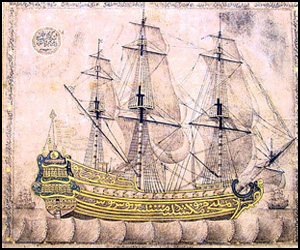
Ottoman Galleon
- Copyright © 2012 - All Rights Reserved -
- Islamic Civilization